Showing posts with label Attractions in South Sumatra. Show all posts

Wednesday, February 13, 2013

7 The Tourism Bogor

Disini saya akan coba menjelaskan nama-nama tempat wisata yang ada Di Bogo

1. Bogor Botanical Gardens / Bogor Palace
This resort has a vast 87 hectares and an icon of the city of Bogor. Tens of thousands of species of plants found there. Besides thousands binataang deer live freely in Bogor Palace yard. Apart from being a tourist spot, the Bogor Botanical Gardens which are the lungs of the city of Bogor is also used for research by students and scientists. High historical value, comfort, coolness, and keasriannya steal the attention of many tourists, including foreign tourists who visit and enjoy the coolness of the woods in the middle of town.


2. The Jungle
Is a family recreation as well as tourism education for students who want to hold a recreation while learning. The Jungle Water Adventure is conveniently located in Bogor Nirwana Residence Housing with the background of Mount Salak. The scenery is beautiful and the cool air is one of the hallmarks of The Jungle is. Different types of interesting rides are there, one of the newest is the Wave Pool (Swimming Waves).


3. Taman Safari Indonesia in Cisarua
Wildlife Safari is a favorite tourist spot for students and schools as well as a study tour one of the family favorites. Taman Safari Indonesia is a zoo in suitable habitat conditioning your animals collection derived from (almost) all over the world. There are also types of rides games and pool.
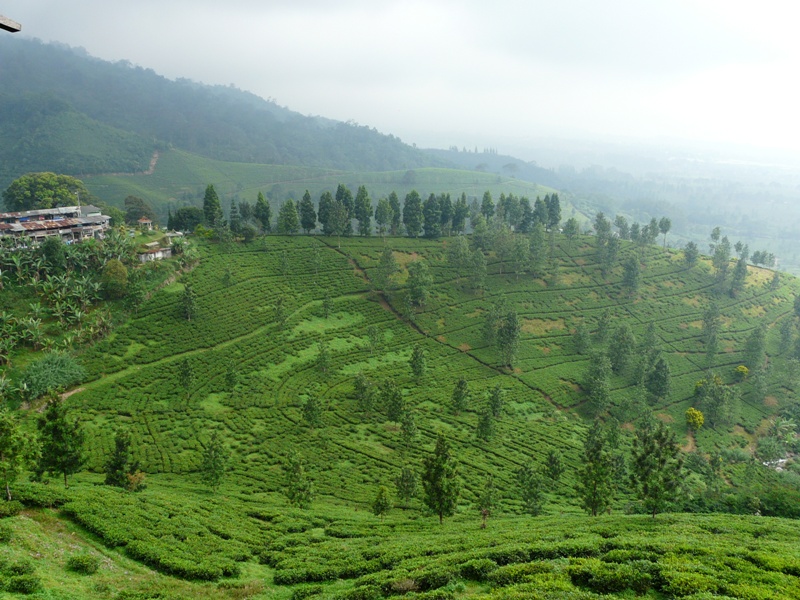

4. Peak
Located on a plateau, surrounded by vast tea gardens, and has a panoramic view of the beautiful and the air is cool. Gunung Mas Tea Plantation is a tourist spot that should be recommended because other than as a study tour can also be used as a convenient place to exercise from walking around the garden tea (tea walk), jogging, cycling up hang gliding sports (kite flying).


5. The Highland Park Resort
The Highland Park Resort is located in the Curug Nangka Ciapus, Sinarwangi Sukajadi Kampung Taman Sari district. It is a typical Mongolian tent building Indonesia's first and only one in Southeast Asia with a view of the exotic lead directly to the Mount Salak. The combination of a cool atmosphere and beautiful nature with a touch of unique interior design make the Highland Park Resort is a luxurious five-star resort in the middle of the wild mountains.


6. Cultural village Sindangbarang
It is the oldest village in Bogor which existed in the Kingdom of Padjadjaran. One of the benefits Sindangbarang Cultural Village is held once a year traditional ceremony "Seren Taun" which is an expression of gratitude to God for the harvest and crops were obtained throughout the year and hope the harvest and crops next year will be even better . Other than that here there is an assortment of Sundanese arts and heritage archaeological sites Padjadjaran kingdom.

Ceremony "Seren Taun" in Kampung Culture Sindangbarang
Rice barn in Kampung Culture Sindangbarang

7. Sentul City Cultural Park
Located in Sentul City, is a tourist destination for families and educational tours for students. It has a large area and the scenery is gorgeous, and the available outbound game. Here, there is also a means to hold the camp, meeting or meetings or corporate office with a cozy atmosphere.

Thursday, February 7, 2013

Tourism in West Kalimantan

You are currently on the road west Kalimantan and want a holiday where ever you are confused here are 10 Tourism in West Kalimantan place you want to try to get there let's consider the following explanation.

 1. Equatorial Monument 
Equator Equator Monument or Monument located on the Equator Road, North Pontianak, West Kalimantan. The location is about 3 km from the center of the city of Pontianak, the direction of the city Mempawah. This monument was to be one of the tourist icons of Pontianak and always visited by the public, especially tourists who come to the city of Pontianak.The history of the construction of this monument can be found on the records contained within the building. In the note stated that: According to the records obtained in 1941 from V. en. W by opzichter Wiese quoted Bijdragen tot de geographie of Chef Van den topographischen dienst in Nederlandsch-Indie: Den 31 sten maart 1928 has come in Pontianak an international expedition led by a Dutch geographer to determine the point / milestone equator line in the city PontianakImportant and wonderful events around the time of the Equator monument is the culmination of the sun, which is a natural phenomenon when the sun right on the equator. At that time the position of the sun will be directly above the head so as to eliminate all shadows of objects on the surface of the earth. At the culmination of the event, shadow monument will "disappear" a few seconds when exposed to sunlight. Likewise, the shadows of other objects around the monument.The event was the culmination of the Sun occurs twice a year, ie between March 21 to 23 and 21 to 23 September. Events of this nature to be an annual event Pontianak attractive tourist arrivals.
2. Pasir Panjang beach 
long sand beachPasir Panjang beach has long been a popular recreation spot, overlooking the sea Natuna and several small islands in the vicinity, including Lemukutan islands, islands and island Kabung Randayan. Small boats and speed boats can be hired here to go to the islands tersebut.Sebagai a place of recreation, tourism has been equipped with supporting facilities as well as around the beach has many hotels, cottages, shops, discotheques and facilities -more facilities available for tourists. This place is perfect for people who love sports swimming, fishing, diving and water skiing or surfing. Pasir Panjang beach located in the District Seventeen, just 17 km from the city center Singkawang. Conditions driveway has been paved and passable by four-wheel vehicles. Means of transportation to and from Pasir Panjang form of public transportation, taxis, minibuses and private vehicles. White sand and rocks that extends along the wind and waves as a safe bathing area, the atmosphere will be felt on Pasir Panjang when the sun rises and sets in the horizon. With Iron Mountain accompanied by a row of trees that shelter and further adds to the elegance and uniqueness of this tourist area. Complete facilities and comfortable that you can see when traveling or on vacation to the beach is Pasir Panjang. Starting inn, family pool, a children's play area, food stalls to sports facilities such as motocross, road race and karting. You can also fish directly into the sea.
3. Sinka Island Park
 
One of the new tourist destination in Singkawang located in the tourist area of ​​Coral Bay / Gulf Ma'jantuh. Located south of the city Singkawang 8 km before entering the city. From the side of the highway Pontianak - Singkawang is 3 km away. Attraction is the future of entertainment offers modern and natural, this seaside tourist area overlooks the beach and other entertainment for families is supported by a variety of amenities, such as wagon and horses for visitors to the park can be rented this recreation. Additionally manager provides a swimming pool, cafeteria and other facilities.
4. Sinka Zoo Zoo 
Sinka Zoo is located next to the Sinka Island Park, precisely in the south with a distance of 500 meters after entering Sinka Island Park. The uniqueness of the zoo is located in various parts around the mountain and seen the beauty of the sea from the top of the mountain featuring endangered animals locally and outside the area, recreational park also has a car to transport travelers to circumnavigate the mountain Bajau. From the top of this mountain, we can see the beauty of the city singkawang clearly.
5. Park Hill Bougenville 
Flower garden is located in the south, precisely in the Village Sijangkung and within ± 6 km from the city Singkawang. His position is located in the foothills of Mount Pasi background and surrounded by forest and plantations. The park has an area of ​​1.5 ha, although the interest Bougenville main view, but there are also a variety of other flowers and arrangement of beautiful garden to be enjoyed by families and young people. The facilities available to visitors of the relative has given the impression of "comfort" to enjoy, ranging from public facilities such as parking, prayer, lodges a place to relax, rest room, cafeteria, mini pool for children up to the homogeneous forest called "Area Super Cool "and can be used for area wedding photography, nature and so on. Equipped hospitality that greet you from every room to the personalized menu offerings. Come and let your eyes and your soul enjoy the beautiful natural scenery in Park Hill Bougainville.
6. Waterfalls cascade MerasapSambas district along the border with the State of Sarawak, there are many waterfalls and cascade are mostly still very natural because it is still untouched by human hands. One of them is quite close to the district capital is Sajingan Great Falls / Merasap cascade that is upstream of the river Sajingan. Called Merasap cascade because of the heavy water cascade raises a cold mist of water spray, because that surrounding residents call cascade is the name cascade Merasap.
 ODTW is unspoiled and has a high selling price to attract the tourists. 20-meter high waterfall, with clear water plus a panorama of natural beauty of the tropical rain forest ecosystem and habitat overgrown tree purchases are still very natural. Uniqueness Merasap cascade, ie, after finding waterfall / cascade, the cascade flows down with only tourists will find one another cascade with a height of 8 feet, which is called; Riam Up Kubik.
7. Randayan IslandThis small island is known for its panoramic beauty of rocks, different types of tropical fish and marine life surrounding. There are small villas overlooking the beautifully verdant sea. Takes 2 hours by speed boat ride from Long Sands Beach.
8. Trench Mountain National ParkTrench Mountain National Park (TNGP) is a national park located in Ketapang District, West Kalimantan, about 30 minute flight from Pontianak. Vast national park is 90,000 hectares, which lies in the District of North Downstream Matan, Sukadana, Simpang Downstream, Nanga Tayap, and Sandai.TNGP ecosystem has arguably the most comprehensive in the national parks in Indonesia. Mountain Trench in the region are having a height of 1116 meters. In addition, TNGP also is habitat for approximately 2200 orangutans. Proboscis monkeys are mammals with the largest number of TNGP.
9. Museum Juanti Sintang Dara dara juantiAs one of the heritage in the City of Sintang, Al Mukarramah palace is now a museum Dara Juanti, save a lot of stories. The palace is located not far from the city center it precisely in the Village of Lower Left Kapuas, save a lot of evidence Sintang track record of past civilizations.
10. Pontianak Sultanate Palace KadariahKadariah Pontianak Sultanate Palace is a palace peningalan period Kadariah empire located in downtown Pontianak Kapuas river and located on the banks of the river Kapuas make this place very nayamn if the visit late afternoon just spend an afternoon if you say to the city of Pontianak Pontianak yet to This court then you are in katakn yet to reach Pontianak city.

LAKE TOBA

Here I will try to write a brief history of the origin of Lake Toba
 
 
HISTORY OF THE ISLAND LAKE TOBA SAMOSIR
 
Lake Toba is a volcanic lake with an area of ​​100 km x 30 km in North Sumatra, Indonesia. In the middle of this lake there is a volcanic island called Samosir Island.

Lake Toba has long become an important tourist destination in
North Sumatra in addition to Bukit Lawang and Nias, attract domestic and foreign tourists.

Estimated that Lake Toba explosion occurred at about 73000-75000 years ago and an eruption Supervolcano (super volcano) the most recent. Bill Rose and Craig Chesner from Michigan Technological University estimate that volcanic materials spewed out the mountain as much as 2800 km3, with 800 km3 and 2000 km3 of rock overlies volcanic ash are expected in the wind to the west for 2 weeks.

Volcanic dust in the wind has spread to half the earth, from china to south africa. Explosion occurred during 1 week and throw the dust up to 10 KM above sea level. This incident caused mass death and in the ultiple species also followed extinction. According to some DNA evidence, this eruption also reduced the number of people to about 60% of the total human population of the earth at that time which is about 60 million people. The eruption also caused the ice ages, alaupun experts are still debating about it. After the eruption, the caldera formed which is then filled with water and became what is now known as Lake Toba. Pressure upward by magma that has not come out cause the emergence of Samosir Island.
  
The Origin of Lake Toba Indeed
Lake Toba was actually derived from a gigantic volcanic eruptions (Supervolcano) that occurred 73 thousand years ago. Toba eruption is the third, the two previous eruptions have happened in a period of 1 million years. The Toba eruption that created Lake Toba is now estimated to have an index of Volcanic Explosion 8 (Mega Colossal) such that form a complex crater measuring 3 thousand sq. km. Eruptive volume is estimated at between two thousand to three thousand cubic km of magma and the 800 km cubic terendapkan as volcanic ash. Explosion is twice the size of the eruption of Mount Tambora in 1815. The eruption of Mount Tambora time generating enough "Year Without a Summer" in the northern hemisphere.

According to Alan Robock, the Toba eruption did not trigger an ice age. Research that analyzes the 6 billion tons of emissions of sulfur dioxide in the simulation shows a maximum global cooling around 15 ° C, three years after the eruption. This means that the line of trees and the snow around 3000 feet lower than now. In recent decades, the climate recovered.

Although there are many different opinions and methods, scientists agree that the Toba super-eruption resulted in ash layers are very thick and the inclusion of toxic gases into atmofer, thus affecting the world's climate period. Some suspect this event triggers an ice age that occurred 1000 years later.

Telling the true Origin of Lake Toba in Children

Science has now advanced enough to know the origin of Lake Toba true. And the story's origin was much more impressive, far more impressive than just a fairy tale. Why teach a fairy tale while science has provided a better explanation of the origin of another spectacular Lake Toba? It seems most of us still do not know about the origin of Lake Toba. And if they do know, they do not know how to communicate scientific facts to children. Here we offer a more spectacular children's story, based on real facts, regarding the origin of Lake Toba.

Once upon a time in the day, There was a hunter who lived in a meadow. He is our ancestor. Their daily work is hunted morning, back to hanging out with his family in the evening.

A new sun goes down at the time. The hunter playing with his wife and children. Another group member starting a fire. Suddenly they were startled by a roar from the sky.
The remaining fracture Map of Lake Toba eruption
At midnight, there was something that came from the sky. Strange rain. Ash. The hunter and his group must leave the place and look for a new place. Abu kept pouring. The hunter and his family tried to west, away from the origin of the ashes. Once a year they went west, they met with the jungle and high mountains. This area is malignant. Although many game animals, but more often the hunters who are eaten by animals. Chiefs decided that the group went to the north and avoid the dense forest in the west.

Thus arose the remaining hunters to the north. In the north they found many food sources, even though the weather was very cold. Animals which are not able to survive in the cold weather and therefore can be easily hunted ensure continuity of the group.

At the end of the ancestors came to a strait. Across the strait no land. Although the same as here, but maybe there is something new in there. The animals here increasingly scarce and increasingly dry climate. So the ancestors made the boat to cross the strait.

Across the strait is an area that was not better than the origin of the ancestors. Here dry, sand and ash everywhere. The ancestors have walked on the beach so as not to get caught in the middle of the desert. They kept walking and walking.

At last they came to a strange world. Gray world, full of ash-covered everything. Seems better here than in the world of sand. Through deliberation, finally ancestors decided to enter the world of gray.

In this gray world, they met with the natives. Those same ancestors. Turns out they are another group who have first got here. They mingle and share stories. They also share the tricks and how to survive. Each member of the group knows how to make a fire because here night and day almost as dark. And without fire they can get lost in the woods.

Over time, dust is no longer down. The sun began to clear. The ancestors decided not to stay in the gray world are now starting to green. They plan to find a new place in the east. They returned adventuring. The number of ancestors very much, only a few people that go on. They are the brave who likes adventure. They penetrate the jungle and climb a high mountain. They met a lot of amazing things. From gems to unique animals. All the obstacles successfully passed, until the ancestor came to a strait.

The ancestors decided to cross the strait and arrive in the land of Sumatra. They walked on to the interior, and finally arrived at a lake. Lake Toba is a large and smoky. They looked at the extraordinary breadth of the lake. It runs beautifully. Ancestors of the most intelligent look at a small ash bursts on the outskirts of the lake. He realized that this is the source of a giant roar of their ancestors ever heard before. This is the reason why the ancestors began to evacuate in the past. This is the cause of our existence here. This is Lake Toba.

The ancients could not have arrived at its destination. And they live around Lake Toba. Time passed and the ancestors continue to breed. They are the ancestors of the tribe of Batak. Batak tribe born here, not long after the birth of Lake Toba. It could be said that the Toba Batak and are brothers. Lake Toba was born and invite ancestors to accompany him. Yes, it is a sign of the birth roar of Lake Toba. He came from a giant volcano eruption gray cast into space. That's the origin of Lake Toba.
 
Comparison with the eruption of Toba eruption more
What exactly do we Teach?


A lot of what we teach through the fairy on top of the problem rather than just a simple life, curses, magic, greed and loyalty. We're talking about how Lake Toba change human evolutionary history. It was a great relationship between lake Toba with all mankind.

The story above is a brief summary of the human migrations over tens of thousands of years, triggered by the Toba eruption. Toba eruption event is catastrophic doomsday for mankind ancestors at the time. From computer simulations, the global temperature is expected to drop about 10 degrees Celsius after the eruption. As a result, in the past ten years occurred in Earth's volcanic winter.

The eruption of Toba gave so much ash in the atmosphere. Closed sunlight and water vapor absorbed into it. In other words, winter is going to be dry. The trees were drastically reduced, as well as pasture and make many extinct mammals and nearly complete history of human evolution.
 
A Male Homo sapiens early
The world becomes a dark, cool and dry for almost twenty years. It is difficult for humans to survive. The principle of evolution says beradaptasilah or you're extinct.

Areas covered include volcanic ash Sumatra, West Java, Kalimantan Western Hemisphere, East Asia and South Asia. This area of ​​the tropics so it is difficult to find a hominid skeleton that gives clues about the lives of our ancestors at that time. Humid tropical environment makes rapid bone crushed before being fossilized. Even so, in the border areas such as southern and eastern Africa, archaeological evidence suggests the existence of a major technological change in that period. An indication of the adaptations made by our ancestors in order to survive. If early humans in Africa that are not covered ash adapt, especially in the area covered by dust, such as India, South Asia.

How big is the adaptations made our ancestors as it depends on what kind of people in Africa or India. Modern man, the real ancestors, not to mention living in Asia period. They came from Africa to Asia 60 thousand years ago, while the Toba eruption occurred 73 thousand years ago.

Early humans living in Asia when the eruption of Toba was Homo erectus. They've lived there for at least a million years, as the evidence of fossils and other Sangiran in Java.

Even so, modern humans apparently already in Israel at 130 thousand years ago and then in Arabic to 85 thousand years ago, based on fossils from Jebel Faya. Our ancestors through two driveways, on the northern tip of the mainland Red Sea and in the southern end of the Red Sea. Both of these areas closer to the parameters of the eruption of Mount Toba ash land bordering on Pakistan. Unfortunately there is no sufficient evidence to show that modern humans evolved in this area of ​​technology to adapt as our ancestors in Eastern and Southern Africa.

When modern humans even exist in the perimeter of the lake Toba eruption in this period, such as India, for example, the technology will grow even more. Or maybe they are destroyed and replaced by our ancestors who are also their ancestors, who came in second wave after the eruption. Modern human populations remaining after the Toba catastrophe can mingle with their new arrivals and adopt their technology. Or perhaps an ancestor of the second wave (H. sapiens) destroys native (H. sapiens) and then also destroy Homo erectus more original again, such as those living in Java. And initiate the human power in South Asia and Southeast Asia, including Indonesia.

There are still a lot of homework that can be done about the scientists of modern human migration paths before and after the Toba catastrophe. Whatever it is, the Toba catastrophe obviously give great meaning to our evolutionary history. It could be that he was the cause of our present existence in Indonesia. Therefore, the origin of scientific fact Toba Lake is much more valuable than the fabled origin of Lake Toba.

Wednesday, February 6, 2013

Attractions in North Sumatra.

Provincial capital in Medan has a lot of interesting attractions. In the province directly adjacent Nangroe Aceh Darussalam, West Sumatra and Riau province, there are attractions which are well known to foreign countries, such as Lake Toba. Here are sights that can be visited in the province of North Sumatra:

Lake Toba and Samosir Island 
[Lake Toba] 
 
Lake Toba and Samosir IslandLake Toba is the largest lake in the world number 2. In the middle of Lake Toba there is Samosir Island. Lake Toba is located about 176 kilometers from the city of Medan. The scenery on the lake is very beautiful, it feels incomplete when the North Sumatra without visiting this attraction. 
Sipiso-piso Waterfall
[Sipiso-piso waterfall] 
Sipiso-piso WaterfallWhat waterfall is located not far from Lake Toba. Named Siposo-piso because when viewed from a distance looks like a knife. This waterfall has a height of 120 meters. This waterfall comes from underground streams coming out of a cave beside the crater of Lake Toba. 
 
Niagara-gura Sigura
[Sigura-gura waterfall] 
 Niagara-gura SiguraAs well as Sipiso-piso waterfall, Niagara-gura Sigura also located not far from Lake Toba. This waterfall is the highest waterfall in Indonesia with an altitude of 250 meters. This waterfall is also used as a Hydroelectric Power Plant (HEPP). 
Bukit Lawang
 
 
[Hill mace]Bukit LawangThis attraction is located in District Bahorok, Langkat regency, North Sumatra. In this area there are Bukit Lawang Gunung Leuser National Park is famous. Views of lush green trees and cool air is characteristic of this attraction. In addition, visitors can see Orang Utan are located in this area. 
Mount Sibayak


[Mountain Sibayak]Mount SibayakMount Sibayak were Karo highlands. Sibayak mountain has an altitude of 2094 meters above sea level. The mountain is not too difficult to climb even a beginner can climb this mountain. From the top of the mountain we could see the view from a distance of Medan. 
Waterfall Two Colors
 
[Two waterfalls colors 
Waterfall Two ColorsThis waterfall is in Sibolangit, Deli Serdang regency. As the name implies, this waterfall is unique in terms of color. The water coming down from the light blue, while the water being stored under a white to gray in color, because the content of phosphorus and sulfur. Visitors are allowed to drink tidk this waterfall. 
Beaches Lagundri
 
 
[Beach Lagundri]Beaches LagundriLagundri beach located in South Nias regency, North Sumatra. The beach is very well known by the world-class professional surfers. The waves at this beach can reach 7-10 meters. On the beach is also often used as an international surfing championships.

Sorake Beach
 

[Sorake Beach]
Sorake BeachSorake Beach is located adjacent to the beach Lagundri. As with Lagundri, Sorake Beach is also a paradise for surfers because the waves were big and rolling.

Attractions in South Sumatra


Sightseeing is also Icon of South Sumatra is the bridge located in Palembang, South Sumatra provincial capital. However Travelers can also visit other tourist attractions located in the province of South Sumatra tourist places are like interesting holiday in South Sumatra.Temam Waterfall

"Attraction in southern Sumatra"

Temam Waterfall South Sumatra 
Place Temam Waterfall Nature Lubuk Linggau South Sumatra ketinggian12 m and width 25 m. The location is surrounded by natural rocks and trees are green with the environment unspoiled nature. This attraction is located 11 km to the south of the city center Lubuk Linggau, Musi Rawas, South Sumatra Province. Lubuk Linggau itself is within 6.5 hours travel by vehicle from Palembang. As another alternative, the city can also be reached via Bengkulu and is about 4 hours drive from Bengkulu.Niagara Falls itself is located ± 50 m from the shaft that connects the Water Village and Village Temam Rahma. For tourists who will visit the region takes ± 30 minutes from downtown Lubuklinggau.Angel Falls

"Holiday to south Sumatra"

 
Lahat Angel Falls in South Sumatra
 Attractions: Angel Falls is located in the village of Karang In, excl. Pulau Pinang, Lahat, Sumatra Selatan.Di called Angel Falls in Niagara said this a common Angel Mandi. To enjoy the Falls is not difficult, from Lahat City is 16 miles or 231 km from Palembang.Di vicinity of Angel Falls, there are 3 more that Niagara Falls Single Girl with a height of about 4 m, Niagara chippy with a height of about 35 m and Dragons Waterfall with a height of about 10 m that can be enjoyed by the flow of water down to the bottom of Angel Falls Waterfall Dragon. 
"South Sumatran tourist sites"

Ampera Bridge Musi River 

The bridge is a bridge community pride Palembang, South Sumatra, and a Trade Mark for the city of Palembang. The existence of the bridge is crucial for connecting the gut and ilir so transportation becomes smooth and automatic also facilitate the economic. This bridge has a length of 1177 meters with a width of 22 meterJembatan Ampera is a gift to the community Bung Karno Palembang with funds drawn from war appropriation funds Jepang.Peresmian made use of the bridge in 1965, precisely on September 30, 1965 By Letjend Ahmad Yani (afternoon Mr. Yani Round and dawn October 1, 65 to Victim G.30 S PKI), once confirmed Bung Karno name as the name of a bridge. However, after the political upheaval in 1966, when the anti-Soekarno very strong, name of the bridge that was converted into a bridge. but people would rather call palembang this bridge as "Musi Project".

In the beginning, the middle body of this bridge can be raised to the top of the mast so that the body does not get caught passing underneath the bridge. The middle of the bridge can be removed with mechanical equipment, two each pendulum weights about 500 tons in the two towers. Appointment speeds around 10 meters per minute with a total time required for full lift bridge for 30 minutes.At the center of the bridge removed, the vessel with the width of 60 meters and a maximum height of 44.50 meters, can pass the River Musi. When the center of the bridge is not raised, the maximum speed boats can pass under the bridge is only nine feet of water surface sungai.Sejak 1970, the bridge is no longer fluctuate. The reason, the time is used to lift the bridge, which is about 30 minutes, is considered disturbing the flow of traffic between Seberang Ulu and Seberang Ilir, two areas separated by Palembang Musi River.Another reason because there is no large ships can sail in Musi River. Superficiality that has exacerbated the cause of the Musi River is not navigable ship large. Until now, the Musi River it continues to silting.Manna River


 "Attraction in Indonesia"
 
Manna River South Sumatra
 Manna River in the District Tanjungsakti Lahat regency, about 40 km from the city Pagaralam, Manna River which divides the southern part of Bengkulu province is located in the upstream part of Sumatra Selata.Sungai have varying difficulty levels, the state of the river is quite wide at the beginning, while along 15 Km following are the narrow path and the current heavy rumble, so it is quite challenging for river rafting sports fans. A river rafting in the form of highly fault (hole) with a rock wall on the outskirts padas river, as well as the current situation at the end of the rapids that make up the basin and flow turning. River rafting Manna have trouble maximum category-IV grade. The natural beauty in the form of the cliffs on either side of the river offers the natural beauty of the tropical rain forest that is very intriguing.Location Jeram Manna early start in the District Tanjungsakti Lahat regency, about 40 km from the city Pagaralam.Waterfall Bedegung

"Sumatran tourist sites in the south"
 
Bedegung Falls South Sumatran
This waterfall is located near the village of Bedegung, Tanjung District Court, about 56 miles south of Muara Enim. Spring water at the crack of Bukit Barisan and down to form a small river rapids. Curup Bedegung handalan a natural tourist attraction area.To facilitate the visitors approached the falls, available path built along 600 meters on the banks of the river and a bridge over a rushing creek that. While on the river available parking lot, food stalls providing food and drink. And slightly downstream, there is a natural baths and fishing, complete with amenities.Natural waterfall is a place of recreation that provides coolness to visitors because of wind gusts that carry water droplets. Natural setting of the surrounding mountains is really impressive.Bumi Ayu Temple

"Temple of the earth attraction ayu southern Sumatra


"Candi Bumi Ayu South Sumatra

Attractions: The temple is situated in the village of Bumi Ayu Bumiayu Tanah Abang Subdistrict. This temple is the only temple complex in South Sumatra, until now no less than 9 pieces temple have been discovered and four of them have been restored, the Temple 1, Temple 2, 3 Temple and Temple 8. This preservation effort started in 1990 until now, supported by state funds. Nevertheless, the role of the Government of the District of Muara Enim quite large, such as Roads, Land Acquisition and Development Field Museum Buildings. Bumiayu enshrinement covers a land area of ​​75.56 hectares, with the outer limit of the form 7 (seven) pieces of river trenches partly already experiencing siltation. Land already owned by the Government of the District of Muara Enim area of ​​6.50 hectares, 69.06 hectares remaining still dominated by the public. The land consists of residential communities, rubber plantations, orange groves, village land and marshes. In accordance with the Master Plan Study Preservation Site Bumiayu South Sumatra in 1996/1997 conducted by the Directorate General of Culture, Ministry of Education and Culture. Gradually the land will be released, since the land is an Archaeological Site. Bumi Ayu Temple at the moment still in the process of assessment and restoration, so not much information is known, while the written information from the temple is still in the process understood by Archeological Assessment Team South Sumatra Province.

Posts Related to South SumatraBengkuluAttractions in Bengkulu Bengkulu Provincial Capital is an old beach town that has the history of the United Kingdom, among others peningalan Fort Marlborough, Thomas Parr Monument, Monument Hamillton, ...West SumatraAttractions in West Sumatra, West Sumatra Province has many places - Travel a very beautiful place and can say international standard, attractions ...Central SulawesiAttractions in Central Sulawesi attractions in Central Sulawesi is a sector that is still to be developed better. This area has the potential of a diverse, ...Riau IslandsAttractions in Riau Riau Islands has various Natural Resources to Make Attraction in an international standard, because tourism sector has become one of the ...JambiAttractions in Jambi Jambi, majority of attractions in Edinburgh at this time not all can be well managed by the government, despite efforts in the direction of ...